Cranbourne North night lights from space
Night Light of Cranbourne North (Victoria) from space (Australia) Src. Average luminocity for 10x10km area is 72.9529% and for 50x50km: 29.0217%.
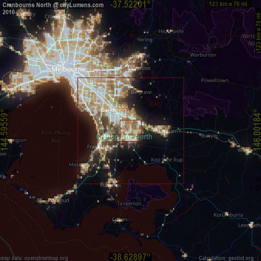
Analysis of Cranbourne North night lights 2016
Square area 10x10 km:
 12.99%
90-99
15.58%80-89
9.9%70-79
15.42%60-69
20.45%50-59
16.88%40-49
1.79%30-39
1.79%20-29
4.22%10-19
0.97%0-9
0%Square area 50x50 km:
5.06%90-99
5.65%80-89
2.9%70-79
5.72%60-69
5.39%50-59
4.59%40-49
3.31%30-39
3.09%20-29
4.5%10-19
10.65%0-9
49.14%Clear (daylight) street map image can be seen on geolist.org.
Map coordinates:
37° 31' 19.2" South, 144° 35' 44.1" East
38° 4' 39.3" South, 145° 17' 55.4" East
38° 37' 44.3" South, 146° 0' 6.6" East
Some cities around Cranbourne North sort by population:
• Berwick
6.7 km =4.2 mi,  42°
42°
• Narre Warren South
3.8 km =2.4 mi,  351°
351°
• Narre Warren
4.9 km =3 mi,  1°
1°
• Hampton Park
6.5 km =4 mi,  319°
319°
• Hallam
7.3 km =4.5 mi,  337°
337°
• Lynbrook
4.4 km =2.7 mi,  302°
302°
• Clyde North
5.3 km =3.3 mi,  145°
145°
• Beaconsfield
6.7 km =4.2 mi,  62°
62°
9972516 (p: 19,900)
Sources (retrieved 2019-11-25):
» Earth at Night: Flat Maps 2012, 2016