Beaconsfield night lights from space
Night Light of Beaconsfield (Victoria) from space (Australia) Src. Average luminocity for 10x10km area is 46.4513% and for 50x50km: 26.3404%.
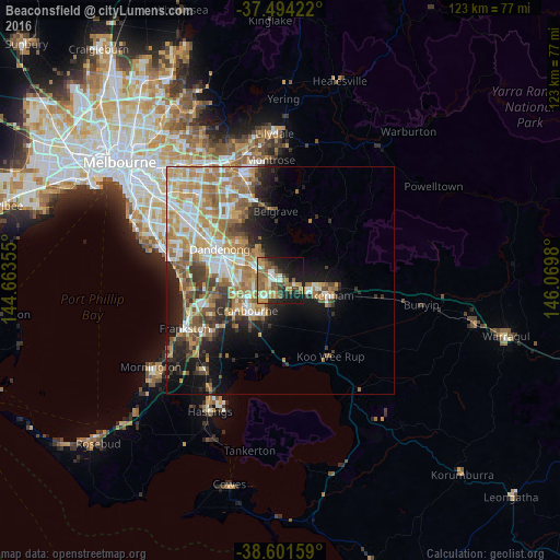
Analysis of Beaconsfield night lights 2016
Square area 10x10 km:
 3.9%
3.9%90-99
8.28%80-89
4.87%70-79
9.42%60-69
6.66%50-59
15.42%40-49
6.82%30-39
4.22%20-29
9.58%10-19
25.32%0-9
5.52%Square area 50x50 km:
4.33%90-99
4.87%80-89
2.63%70-79
5.41%60-69
5.52%50-59
4.23%40-49
3.01%30-39
3.06%20-29
4.09%10-19
9.23%0-9
53.63%Clear (daylight) street map image can be seen on geolist.org.
Map coordinates:
37° 29' 39.2" South, 144° 39' 48.8" East
38° 3' 0" South, 145° 22' 0" East
38° 36' 5.7" South, 146° 4' 11.3" East
Some cities around Beaconsfield sort by population:
• Berwick
2.4 km =1.5 mi,  321°
321°
• Narre Warren South
6.5 km =4 mi,  276°
276°
• Narre Warren
6.1 km =3.8 mi,  287°
287°
• Cranbourne North
6.7 km =4.2 mi,  242°
242°
• Cranbourne East
9.4 km =5.8 mi,  219°
219°
• Clyde North
8 km =5 mi,  201°
201°
• Narre Warren North
8.6 km =5.3 mi,  329°
329°
• Officer
3.9 km =2.4 mi,  105°
105°
2176542 (p: 6,614)
Sources (retrieved 2019-11-25):
» Earth at Night: Flat Maps 2012, 2016