Cannon Hill night lights from space
Night Light of Cannon Hill (Queensland) from space (Australia) Src. Average luminocity for 10x10km area is 89.9544% and for 50x50km: 44.2588%.
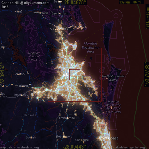
Analysis of Cannon Hill night lights 2016
Square area 10x10 km:
 28.37%
90-99
34.92%80-89
10.91%70-79
18.85%60-69
5.56%50-59
1.39%40-49
0%30-39
0%20-29
0%10-19
0%0-9
0%Square area 50x50 km:
8.67%90-99
9.54%80-89
5.73%70-79
6.44%60-69
11.68%50-59
4.13%40-49
4.17%30-39
4.19%20-29
6.88%10-19
9.77%0-9
28.8%Clear (daylight) street map image can be seen on geolist.org.
Map coordinates:
26° 50' 48.4" South, 152° 23' 29.9" East
27° 28' 20.5" South, 153° 5' 41.1" East
28° 5' 39.9" South, 153° 47' 52.4" East
Some cities around Cannon Hill sort by population:
• Coorparoo
4.3 km =2.7 mi,  237°
237°
• Carindale
3.8 km =2.4 mi,  168°
168°
• Camp Hill
3 km =1.9 mi,  217°
217°
• Morningside
2.3 km =1.4 mi,  301°
301°
• Tingalpa
3.2 km =2 mi,  92°
92°
• Carina Heights
3.9 km =2.4 mi,  185°
185°
• Bulimba
4.4 km =2.7 mi, 304°
• Norman Park
3.3 km =2.1 mi,  256°
256°
8348393 (p: 5,481)
Sources (retrieved 2019-11-25):
» Earth at Night: Flat Maps 2012, 2016