Carindale night lights from space
Night Light of Carindale (Queensland) from space (Australia) Src. Average luminocity for 10x10km area is 79.5813% and for 50x50km: 44.6732%.
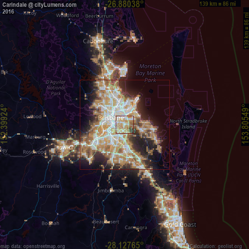
Analysis of Carindale night lights 2016
Square area 10x10 km:
 14.09%
90-99
20.63%80-89
14.48%70-79
26.59%60-69
14.09%50-59
3.17%40-49
2.38%30-39
4.56%20-29
0%10-19
0%0-9
0%Square area 50x50 km:
8.65%90-99
9.49%80-89
5.65%70-79
6.54%60-69
12%50-59
3.97%40-49
4.26%30-39
4.28%20-29
7.45%10-19
10.44%0-9
27.26%Clear (daylight) street map image can be seen on geolist.org.
Map coordinates:
26° 52' 49.4" South, 152° 23' 57.3" East
27° 30' 20.8" South, 153° 6' 8.5" East
28° 7' 39.5" South, 153° 48' 19.8" East
Some cities around Carindale sort by population:
• Coorparoo
4.6 km =2.9 mi,  287°
287°
• Mount Gravatt East
4.3 km =2.7 mi,  207°
207°
• Camp Hill
2.9 km =1.8 mi,  297°
297°
• Mansfield
3.7 km =2.3 mi,  185°
185°
• Tingalpa
4.3 km =2.7 mi,  34°
34°
• Holland Park
3.7 km =2.3 mi,  250°
250°
• Holland Park West
4.7 km =2.9 mi,  241°
241°
• Cannon Hill
3.8 km =2.4 mi,  348°
348°
7281839 (p: 15,418)
Sources (retrieved 2019-11-25):
» Earth at Night: Flat Maps 2012, 2016