Camp Hill night lights from space
Night Light of Camp Hill (Queensland) from space (Australia) Src. Average luminocity for 10x10km area is 89.7321% and for 50x50km: 45.2006%.
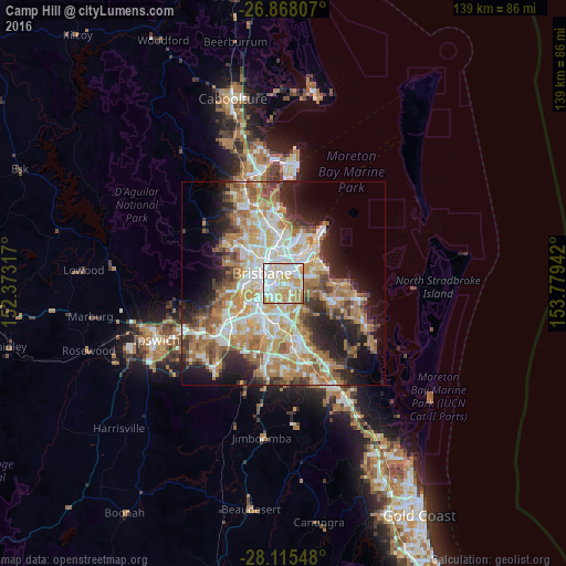
Analysis of Camp Hill night lights 2016
Square area 10x10 km:
 27.18%
90-99
31.35%80-89
15.28%70-79
21.63%60-69
4.56%50-59
0%40-49
0%30-39
0%20-29
0%10-19
0%0-9
0%Square area 50x50 km:
8.76%90-99
9.51%80-89
5.62%70-79
6.53%60-69
12.16%50-59
4.17%40-49
4.5%30-39
4.54%20-29
7.45%10-19
10.81%0-9
25.94%Clear (daylight) street map image can be seen on geolist.org.
Map coordinates:
26° 52' 5.1" South, 152° 22' 23.4" East
27° 29' 36.7" South, 153° 4' 34.6" East
28° 6' 55.7" South, 153° 46' 45.9" East
Some cities around Camp Hill sort by population:
• Coorparoo
1.8 km =1.1 mi,  271°
271°
• Carindale
2.9 km =1.8 mi,  117°
117°
• Greenslopes
3.1 km =1.9 mi,  238°
238°
• Holland Park
2.8 km =1.7 mi,  198°
198°
• Carina Heights
2.1 km =1.3 mi,  135°
135°
• Norman Park
2.1 km =1.3 mi,  319°
319°
• East Brisbane
3.5 km =2.2 mi,  293°
293°
• Cannon Hill
3 km =1.9 mi,  37°
37°
9957444 (p: 10,932)
Sources (retrieved 2019-11-25):
» Earth at Night: Flat Maps 2012, 2016