Carina Heights night lights from space
Night Light of Carina Heights (Queensland) from space (Australia) Src. Average luminocity for 10x10km area is 83.3313% and for 50x50km: 45.1021%.
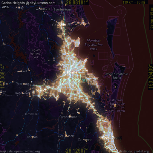
Analysis of Carina Heights night lights 2016
Square area 10x10 km:
 17.46%
90-99
23.41%80-89
16.27%70-79
27.58%60-69
10.71%50-59
1.39%40-49
1.79%30-39
1.39%20-29
0%10-19
0%0-9
0%Square area 50x50 km:
8.7%90-99
9.56%80-89
5.68%70-79
6.54%60-69
12.1%50-59
3.98%40-49
4.34%30-39
4.49%20-29
7.58%10-19
10.81%0-9
26.21%Clear (daylight) street map image can be seen on geolist.org.
Map coordinates:
26° 52' 54.5" South, 152° 23' 17.3" East
27° 30' 26" South, 153° 5' 28.5" East
28° 7' 44.7" South, 153° 47' 39.8" East
Some cities around Carina Heights sort by population:
• Coorparoo
3.6 km =2.2 mi,  295°
295°
• Mount Gravatt East
3.8 km =2.4 mi,  193°
193°
• Camp Hill
2.1 km =1.3 mi,  315°
315°
• Greenslopes
4.1 km =2.5 mi,  268°
268°
• Mansfield
3.6 km =2.2 mi,  167°
167°
• Holland Park
2.6 km =1.6 mi,  245°
245°
• Holland Park West
3.7 km =2.3 mi,  235°
235°
• Cannon Hill
3.9 km =2.4 mi,  5°
5°
8348397 (p: 6,725)
Sources (retrieved 2019-11-25):
» Earth at Night: Flat Maps 2012, 2016