Tingalpa night lights from space
Night Light of Tingalpa (Queensland) from space (Australia) Src. Average luminocity for 10x10km area is 81.5% and for 50x50km: 43.2458%.
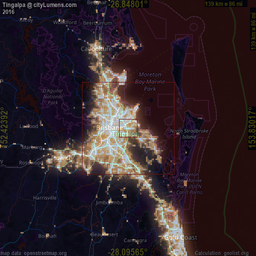
Analysis of Tingalpa night lights 2016
Square area 10x10 km:
 20.63%
90-99
22.02%80-89
7.94%70-79
22.62%60-69
17.46%50-59
4.17%40-49
5.16%30-39
0%20-29
0%10-19
0%0-9
0%Square area 50x50 km:
8.55%90-99
9.35%80-89
5.72%70-79
6.46%60-69
11.21%50-59
3.98%40-49
3.95%30-39
3.93%20-29
6.61%10-19
9.38%0-9
30.86%Clear (daylight) street map image can be seen on geolist.org.
Map coordinates:
26° 50' 52.8" South, 152° 25' 26.1" East
27° 28' 25" South, 153° 7' 37.3" East
28° 5' 44.3" South, 153° 49' 48.6" East
Some cities around Tingalpa sort by population:
• Carindale
4.3 km =2.7 mi,  214°
214°
• Wynnum
4.4 km =2.7 mi,  44°
44°
• Wynnum West
3.1 km =1.9 mi,  56°
56°
• Manly West
3.9 km =2.4 mi,  90°
90°
• Morningside
5.3 km =3.3 mi,  284°
284°
• Wakerley
3 km =1.9 mi,  110°
110°
• Carina Heights
5.1 km =3.2 mi,  223°
223°
• Cannon Hill
3.2 km =2 mi,  272°
272°
8348945 (p: 8,051)
Sources (retrieved 2019-11-25):
» Earth at Night: Flat Maps 2012, 2016