Mīrābād night lights from space
Night Light of Mīrābād (Nimroz) from space (Afghanistan) Src. Average luminocity for 10x10km area is 0% and for 50x50km: 0%.
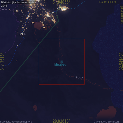
Analysis of Mīrābād night lights 2016
Square area 10x10 km:
 0%
0%90-99
0%80-89
0%70-79
0%60-69
0%50-59
0%40-49
0%30-39
0%20-29
0%10-19
0%0-9
100%Square area 50x50 km:
0%90-99
0%80-89
0%70-79
0%60-69
0%50-59
0%40-49
0%30-39
0%20-29
0%10-19
0%0-9
100%Clear (daylight) street map image can be seen on geolist.org.
Map coordinates:
31° 2' 26.1" North, 61° 8' 6.6" East
30° 26' 10.5" North, 61° 50' 17.9" East
29° 49' 41.3" North, 62° 32' 29.1" East
Some cities around Mīrābād sort by population:
• Zahedan, IR
140.5 km =87.3 mi,  221°
221°
• Zābol, IR
73.8 km =45.9 mi,  333°
333°
• Zaranj
58.2 km =36.2 mi,  2°
2°
• Farah
217.1 km =134.9 mi,  6°
6°
• Khāsh
151.7 km =94.3 mi,  36°
36°
• Rūdbār
79.8 km =49.6 mi,  113°
113°
• ‘Alāqahdārī Dīshū
139.9 km =86.9 mi,  90°
90°
• Markaz-e Ḩukūmat-e Darwēshān
237.9 km =147.8 mi,  71°
71°
1133310 (p: 14,160)
Sources (retrieved 2019-11-25):
» Earth at Night: Flat Maps 2012, 2016