Chambishi night lights from space
Night Light of Chambishi (Copperbelt) from space (Zambia) Src. Average luminocity for 10x10km area is 21.6082% and for 50x50km: 12.2536%.
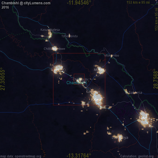
Analysis of Chambishi night lights 2016
Square area 10x10 km:
 2.6%
2.6%90-99
2.16%80-89
2.6%70-79
1.73%60-69
4.11%50-59
3.9%40-49
5.84%30-39
3.9%20-29
1.52%10-19
11.69%0-9
59.96%Square area 50x50 km:
2.06%90-99
2.75%80-89
0.82%70-79
1.09%60-69
1.54%50-59
1.67%40-49
2.01%30-39
1.5%20-29
2.54%10-19
8.34%0-9
75.68%Clear (daylight) street map image can be seen on geolist.org.
Map coordinates:
11° 56' 43.7" South, 27° 21' 2" East
12° 37' 56.9" South, 28° 3' 13.2" East
13° 19' 3.5" South, 28° 45' 24.5" East
Some cities around Chambishi sort by population:
• Kitwe
25.6 km =15.9 mi,  137°
137°
• Ndola
72.9 km =45.3 mi,  119°
119°
• Chingola
21.7 km =13.5 mi,  301°
301°
• Mufulira
22.3 km =13.9 mi,  65°
65°
• Luanshya
68.5 km =42.6 mi, 144°
• Kalulushi
23.7 km =14.7 mi,  169°
169°
• Chililabombwe
38.9 km =24.2 mi,  319°
319°
• Mpongwe
98.1 km =61 mi, 173°
920820 (p: 11,073)
Sources (retrieved 2019-11-25):
» Earth at Night: Flat Maps 2012, 2016