Tzaneen night lights from space
Night Light of Tzaneen (Limpopo) from space (South Africa) Src. Average luminocity for 10x10km area is 29.4226% and for 50x50km: 12.7904%.
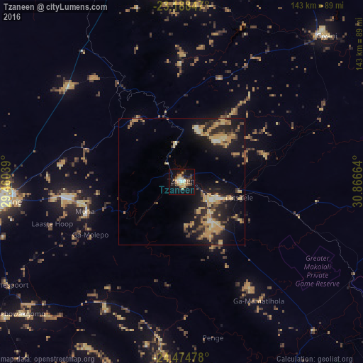
Analysis of Tzaneen night lights 2016
Square area 10x10 km:
 1.79%
1.79%90-99
4.76%80-89
7.14%70-79
3.57%60-69
4.17%50-59
2.58%40-49
2.98%30-39
4.56%20-29
5.16%10-19
33.33%0-9
29.96%Square area 50x50 km:
0.37%90-99
0.84%80-89
2.47%70-79
4.04%60-69
1.21%50-59
1.17%40-49
1.87%30-39
1.87%20-29
4.55%10-19
11.06%0-9
70.54%Clear (daylight) street map image can be seen on geolist.org.
Map coordinates:
23° 11' 18.5" South, 29° 27' 37.4" East
23° 49' 59.6" South, 30° 9' 48.6" East
24° 28' 29.2" South, 30° 51' 59.9" East
Some cities around Tzaneen sort by population:
• Polokwane
71.1 km =44.2 mi,  263°
263°
• Louis Trichardt
91.7 km =57 mi,  343°
343°
• Giyani
81.8 km =50.8 mi,  43°
43°
• Lebowakgomo
78.8 km =49 mi,  238°
238°
• Nkowakowa
14 km =8.7 mi,  115°
115°
• Duiwelskloof
15.7 km =9.8 mi,  351°
351°
• Ga-Kgapane
21.9 km =13.6 mi,  16°
16°
• Mankoeng
36 km =22.4 mi, 258°
946973 (p: 16,954)
Sources (retrieved 2019-11-25):
» Earth at Night: Flat Maps 2012, 2016