Ga-Kgapane night lights from space
Night Light of Ga-Kgapane (Limpopo) from space (South Africa) Src. Average luminocity for 10x10km area is 27.6548% and for 50x50km: 9.1809%.
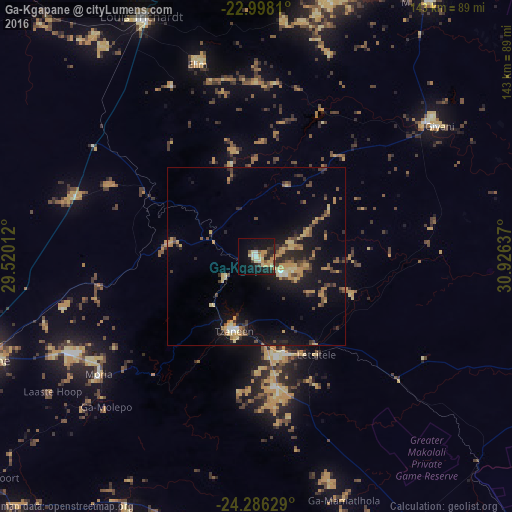
Analysis of Ga-Kgapane night lights 2016
Square area 10x10 km:
 0.99%
0.99%90-99
4.17%80-89
6.15%70-79
7.34%60-69
0.79%50-59
2.38%40-49
3.17%30-39
3.17%20-29
9.92%10-19
24.8%0-9
37.1%Square area 50x50 km:
0.18%90-99
0.55%80-89
1.66%70-79
1.92%60-69
1.05%50-59
1.2%40-49
1.81%30-39
1.32%20-29
2.68%10-19
7.94%0-9
79.68%Clear (daylight) street map image can be seen on geolist.org.
Map coordinates:
22° 59' 53.2" South, 29° 31' 12.4" East
23° 38' 37.6" South, 30° 13' 23.7" East
24° 17' 10.6" South, 30° 55' 34.9" East
Some cities around Ga-Kgapane sort by population:
• Polokwane
82.1 km =51 mi,  249°
249°
• Louis Trichardt
74.3 km =46.2 mi,  333°
333°
• Thohoyandou
82.1 km =51 mi,  19°
19°
• Giyani
63.2 km =39.3 mi,  53°
53°
• Nkowakowa
27.9 km =17.3 mi,  166°
166°
• Duiwelskloof
10.1 km =6.3 mi,  236°
236°
• Tzaneen
21.9 km =13.6 mi,  196°
196°
• Mankoeng
50.2 km =31.2 mi, 235°
1003462 (p: 13,000)
Sources (retrieved 2019-11-25):
» Earth at Night: Flat Maps 2012, 2016