Ekuvukeni night lights from space
Night Light of Ekuvukeni (KwaZulu-Natal) from space (South Africa) Src. Average luminocity for 10x10km area is 2.7996% and for 50x50km: 0.8762%.
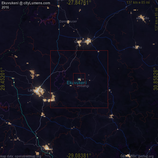
Analysis of Ekuvukeni night lights 2016
Square area 10x10 km:
 0%
0%90-99
0%80-89
0.4%70-79
0.79%60-69
1.19%50-59
0.79%40-49
0%30-39
0.79%20-29
0%10-19
0.79%0-9
95.24%Square area 50x50 km:
0%90-99
0%80-89
0.1%70-79
0.38%60-69
0.25%50-59
0.06%40-49
0.14%30-39
0.1%20-29
0.17%10-19
0.32%0-9
98.48%Clear (daylight) street map image can be seen on geolist.org.
Map coordinates:
27° 50' 51.4" South, 29° 27' 7.2" East
28° 28' 3.1" South, 30° 9' 18.5" East
29° 5' 1.7" South, 30° 51' 29.7" East
Some cities around Ekuvukeni sort by population:
• Newcastle
81.9 km =50.9 mi,  344°
344°
• Vryheid
99.6 km =61.9 mi,  38°
38°
• Dundee
34.3 km =21.3 mi,  12°
12°
• Mondlo
77.1 km =47.9 mi,  45°
45°
• Harrismith
102.7 km =63.8 mi,  282°
282°
• Greytown
78.9 km =49 mi,  147°
147°
• Glencoe
32.2 km =20 mi,  358°
358°
• Mooirivier
83.8 km =52.1 mi,  190°
190°
1006420 (p: 14,331)
Sources (retrieved 2019-11-25):
» Earth at Night: Flat Maps 2012, 2016