Bochum night lights from space
Night Light of Bochum (Limpopo) from space (South Africa) Src. Average luminocity for 10x10km area is 10.1364% and for 50x50km: 1.338%.
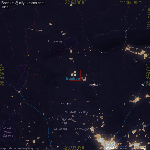
Analysis of Bochum night lights 2016
Square area 10x10 km:
 0%
0%90-99
0%80-89
4.92%70-79
1.14%60-69
0.76%50-59
2.27%40-49
1.52%30-39
1.33%20-29
0.95%10-19
0%0-9
87.12%Square area 50x50 km:
0%90-99
0%80-89
0.27%70-79
0.22%60-69
0.25%50-59
0.23%40-49
0.38%30-39
0.37%20-29
0.35%10-19
0.17%0-9
97.76%Clear (daylight) street map image can be seen on geolist.org.
Map coordinates:
22° 38' 19.2" South, 28° 26' 11.5" East
23° 17' 9.9" South, 29° 8' 22.7" East
23° 55' 49.3" South, 29° 50' 34" East
Some cities around Bochum sort by population:
• Polokwane
76.5 km =47.5 mi,  153°
153°
• Mokopane
101.9 km =63.3 mi,  187°
187°
• Louis Trichardt
82.6 km =51.3 mi,  70°
70°
• Lebowakgomo
108 km =67.1 mi,  160°
160°
• Duiwelskloof
111.6 km =69.3 mi,  113°
113°
• Tzaneen
120.8 km =75.1 mi,  120°
120°
• Ga-Kgapane
117.5 km =73 mi, 109°
• Mankoeng
97 km =60.3 mi,  134°
134°
1018148 (p: 12,000)
Sources (retrieved 2019-11-25):
» Earth at Night: Flat Maps 2012, 2016