Gia Nghĩa night lights from space
Night Light of Gia Nghĩa (Ðắk Nông) from space (Vietnam) Src. Average luminocity for 10x10km area is 25.7417% and for 50x50km: 1.7229%.
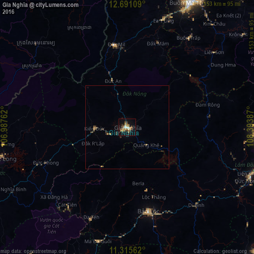
Analysis of Gia Nghĩa night lights 2016
Square area 10x10 km:
 1.24%
1.24%90-99
2.07%80-89
4.75%70-79
5.58%60-69
6.61%50-59
0.41%40-49
4.75%30-39
3.51%20-29
5.79%10-19
18.39%0-9
46.9%Square area 50x50 km:
0.05%90-99
0.08%80-89
0.23%70-79
0.4%60-69
0.3%50-59
0.08%40-49
0.47%30-39
0.37%20-29
0.4%10-19
0.88%0-9
96.73%Clear (daylight) street map image can be seen on geolist.org.
Map coordinates:
12° 41' 27.9" North, 106° 59' 15.4" East
12° 0' 15.2" North, 107° 41' 26.7" East
11° 18' 56.2" North, 108° 23' 37.9" East
Some cities around Gia Nghĩa sort by population:
• Ðà Lạt
82 km =51 mi,  94°
94°
• Đưc Trọng
80.1 km =49.8 mi,  111°
111°
• Bảo Lộc
52.3 km =32.5 mi,  165°
165°
• Buôn Ma Thuột
82.8 km =51.4 mi,  27°
27°
• Don Luan
102.2 km =63.5 mi,  239°
239°
• Đinh Văn
64.8 km =40.3 mi, 111°
• Bình Long
124.6 km =77.4 mi,  251°
251°
• Sen Monorom, KH
74.2 km =46.1 mi,  312°
312°
1581834 (p: 0)
Sources (retrieved 2019-11-25):
» Earth at Night: Flat Maps 2012, 2016