Sen Monorom night lights from space
Night Light of Sen Monorom (Mondolkiri) from space (Cambodia) Src. Average luminocity for 10x10km area is 0.5785% and for 50x50km: 0.0236%.
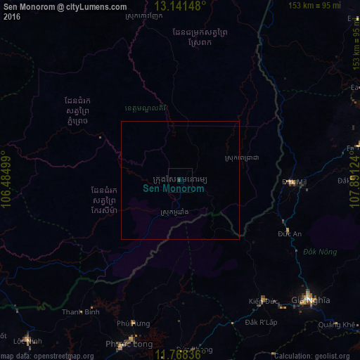
Analysis of Sen Monorom night lights 2016
Square area 10x10 km:
 0%
0%90-99
0%80-89
0%70-79
0%60-69
0%50-59
0%40-49
0%30-39
1.65%20-29
0%10-19
0%0-9
98.35%Square area 50x50 km:
0%90-99
0%80-89
0%70-79
0%60-69
0%50-59
0%40-49
0%30-39
0.07%20-29
0%10-19
0%0-9
99.93%Clear (daylight) street map image can be seen on geolist.org.
Map coordinates:
13° 8' 29.3" North, 106° 29' 6" East
12° 27' 21" North, 107° 11' 17.2" East
11° 46' 6.1" North, 107° 53' 28.5" East
Some cities around Sen Monorom sort by population:
• Bảo Lộc, VN
121.4 km =75.4 mi,  146°
146°
• Buôn Ma Thuột, VN
95.2 km =59.2 mi,  75°
75°
• Don Luan, VN
107.6 km =66.9 mi,  197°
197°
• Kratié
127 km =78.9 mi,  271°
271°
• Lumphat
117.3 km =72.9 mi,  348°
348°
• Đinh Văn, VN
136.7 km =84.9 mi,  122°
122°
• Bình Long, VN
110 km =68.4 mi,  215°
215°
• Gia Nghĩa, VN
74.2 km =46.1 mi,  132°
132°
1822227 (p: 7,944)
Sources (retrieved 2019-11-25):
» Earth at Night: Flat Maps 2012, 2016