Tucacas night lights from space
Night Light of Tucacas (Falcón) from space (Venezuela) Src. Average luminocity for 10x10km area is 25.3037% and for 50x50km: 3.4648%.
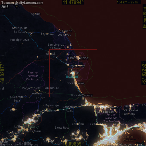
Analysis of Tucacas night lights 2016
Square area 10x10 km:
 2.48%
2.48%90-99
2.48%80-89
0.62%70-79
8.88%60-69
4.96%50-59
2.89%40-49
1.86%30-39
1.65%20-29
2.89%10-19
30.37%0-9
40.91%Square area 50x50 km:
0.13%90-99
0.16%80-89
0.05%70-79
1.51%60-69
0.68%50-59
0.43%40-49
0.38%30-39
0.29%20-29
0.28%10-19
2.25%0-9
93.84%Clear (daylight) street map image can be seen on geolist.org.
Map coordinates:
11° 28' 47.8" North, 69° 1' 43.6" West
10° 47' 24.2" North, 68° 19' 32.3" West
10° 5' 54.9" North, 67° 37' 21.1" West
Some cities around Tucacas sort by population:
• Valencia
78 km =48.5 mi,  153°
153°
• Puerto Cabello
49.1 km =30.5 mi,  135°
135°
• Guacara
79.6 km =49.5 mi, 141°
• San Felipe
67.7 km =42.1 mi,  222°
222°
• Morón
36.3 km =22.6 mi,  157°
157°
• San Joaquín
82.8 km =51.4 mi, 135°
• Nirgua
75.8 km =47.1 mi,  200°
200°
• Chichiriviche
16.5 km =10.3 mi,  20°
20°
3625965 (p: 12,500)
Sources (retrieved 2019-11-25):
» Earth at Night: Flat Maps 2012, 2016