Bo‘ka night lights from space
Night Light of Bo‘ka (Toshkent) from space (Uzbekistan) Src. Average luminocity for 10x10km area is 21.119% and for 50x50km: 4.0222%.
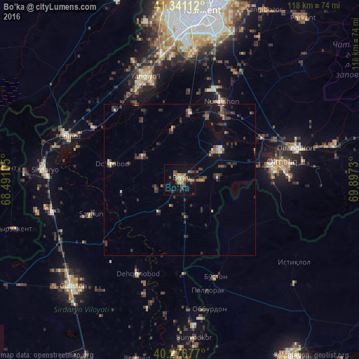
Analysis of Bo‘ka night lights 2016
Square area 10x10 km:
 0.34%
0.34%90-99
0.68%80-89
3.23%70-79
3.23%60-69
7.14%50-59
3.06%40-49
2.89%30-39
4.59%20-29
2.72%10-19
19.22%0-9
52.89%Square area 50x50 km:
0.14%90-99
0.25%80-89
0.31%70-79
0.41%60-69
0.62%50-59
0.45%40-49
0.91%30-39
1.64%20-29
1.42%10-19
1.78%0-9
92.07%Clear (daylight) street map image can be seen on geolist.org.
Map coordinates:
41° 20' 28" North, 68° 29' 27.8" East
40° 48' 39.9" North, 69° 11' 39" East
40° 16' 36.4" North, 69° 53' 50.3" East
Some cities around Bo‘ka sort by population:
• Olmaliq
34.2 km =21.3 mi,  83°
83°
• Yangiyŭl
35.7 km =22.2 mi,  339°
339°
• Ohangaron
38.8 km =24.1 mi,  74°
74°
• Piskent
16.3 km =10.1 mi,  53°
53°
• Zafar
31.3 km =19.4 mi,  307°
307°
• Tŭytepa
28.4 km =17.6 mi,  29°
29°
• Bŭston, TJ
34.1 km =21.2 mi,  159°
159°
• Amir Timur
31.5 km =19.6 mi,  317°
317°
1514330 (p: 19,642)
Sources (retrieved 2019-11-25):
» Earth at Night: Flat Maps 2012, 2016