Zafar night lights from space
Night Light of Zafar (Toshkent) from space (Uzbekistan) Src. Average luminocity for 10x10km area is 4.898% and for 50x50km: 7.5252%.
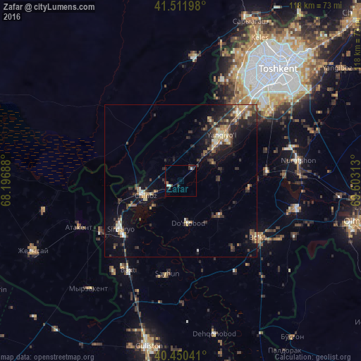

Analysis of Zafar night lights 2016
Square area 10x10 km:
 0.34%
0.34%90-99
1.7%80-89
0%70-79
0%60-69
0%50-59
0.68%40-49
0.85%30-39
2.89%20-29
1.36%10-19
1.02%0-9
91.16%Square area 50x50 km:
0.25%90-99
1.11%80-89
0.97%70-79
0.63%60-69
1.11%50-59
1.19%40-49
1.14%30-39
2.26%20-29
2.67%10-19
5.25%0-9
83.42%Clear (daylight) street map image can be seen on geolist.org.
Map coordinates:
41° 30' 43.1" North, 68° 11' 48.8" East
40° 58' 60" North, 68° 54' 0" East
40° 27' 1.5" North, 69° 36' 11.3" East
Some cities around Zafar sort by population:
• Yangiyŭl
18.9 km =11.7 mi,  40°
40°
• Piskent
39 km =24.2 mi,  104°
104°
• Sirdaryo
25.3 km =15.7 mi,  232°
232°
• Chinoz
12.8 km =8 mi,  245°
245°
• Bo‘ka
31.3 km =19.4 mi,  127°
127°
• Ŭrtaowul
30.6 km =19 mi, 42°
• Atakent, KZ
36.3 km =22.6 mi, 245°
• Amir Timur
5.3 km =3.3 mi, 40°
1512287 (p: 24,781)
Sources (retrieved 2019-11-25):
» Earth at Night: Flat Maps 2012, 2016