Zephyrhills West night lights from space
Night Light of Zephyrhills West (Florida) from space (United States) Src. Average luminocity for 10x10km area is 60.7202% and for 50x50km: 35.7183%.
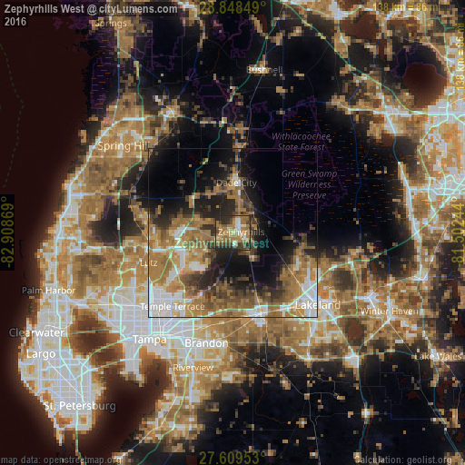
Analysis of Zephyrhills West night lights 2016
Square area 10x10 km:
 3.77%
3.77%90-99
8.33%80-89
6.55%70-79
10.71%60-69
33.53%50-59
5.95%40-49
11.11%30-39
6.94%20-29
13.1%10-19
0%0-9
0%Square area 50x50 km:
5.09%90-99
5.17%80-89
2.47%70-79
4.84%60-69
13.47%50-59
5.35%40-49
5.32%30-39
5.28%20-29
7.19%10-19
11.17%0-9
34.64%Clear (daylight) street map image can be seen on geolist.org.
Map coordinates:
28° 50' 54.6" North, 82° 54' 31.3" West
28° 13' 50.9" North, 82° 12' 20" West
27° 36' 34.3" North, 81° 30' 8.8" West
Some cities around Zephyrhills West sort by population:
• Wesley Chapel
12 km =7.5 mi,  274°
274°
• Plant City
25.2 km =15.7 mi,  159°
159°
• Land O' Lakes
24.7 km =15.3 mi, 266°
• Thonotosassa
21.1 km =13.1 mi,  206°
206°
• Pebble Creek
16.5 km =10.3 mi,  236°
236°
• Pasadena Hills
5.8 km =3.6 mi,  341°
341°
• Dade City
14.9 km =9.3 mi,  3°
3°
• Kathleen
21.7 km =13.5 mi,  124°
124°
7260320 (p: 5,865)
Sources (retrieved 2019-11-25):
» Earth at Night: Flat Maps 2012, 2016