Pasadena Hills night lights from space
Night Light of Pasadena Hills (Florida) from space (United States) Src. Average luminocity for 10x10km area is 42.371% and for 50x50km: 30.0744%.
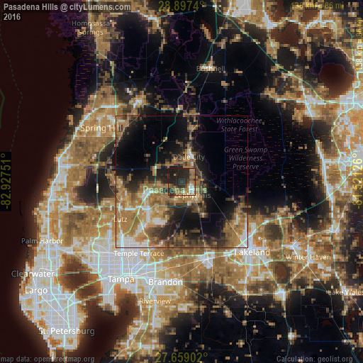
Analysis of Pasadena Hills night lights 2016
Square area 10x10 km:
 2.98%
2.98%90-99
4.17%80-89
1.98%70-79
3.97%60-69
18.45%50-59
6.35%40-49
7.14%30-39
3.77%20-29
32.14%10-19
19.05%0-9
0%Square area 50x50 km:
2.75%90-99
3.37%80-89
2.1%70-79
4.11%60-69
12.63%50-59
4.44%40-49
4.86%30-39
5.8%20-29
7.36%10-19
12.47%0-9
40.09%Clear (daylight) street map image can be seen on geolist.org.
Map coordinates:
28° 53' 50.6" North, 82° 55' 39" West
28° 16' 48" North, 82° 13' 27.8" West
27° 39' 32.5" North, 81° 31' 16.5" West
Some cities around Pasadena Hills sort by population:
• Wesley Chapel
11.1 km =6.9 mi,  246°
246°
• Land O' Lakes
23.8 km =14.8 mi, 253°
• Zephyrhills
6.7 km =4.2 mi,  140°
140°
• Thonotosassa
25.5 km =15.8 mi,  197°
197°
• Pebble Creek
18.9 km =11.7 mi,  219°
219°
• Dade City
9.8 km =6.1 mi,  16°
16°
• Zephyrhills West
5.8 km =3.6 mi,  161°
161°
• Zephyrhills South
8 km =5 mi,  154°
154°
7315238 (p: 7,570)
Sources (retrieved 2019-11-25):
» Earth at Night: Flat Maps 2012, 2016