Dade City night lights from space
Night Light of Dade City (Florida) from space (United States) Src. Average luminocity for 10x10km area is 39.6548% and for 50x50km: 21.3426%.
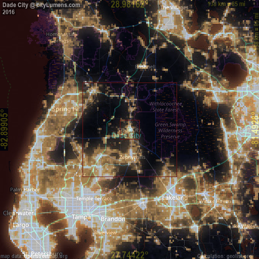
Analysis of Dade City night lights 2016
Square area 10x10 km:
 2.58%
2.58%90-99
3.77%80-89
3.37%70-79
2.78%60-69
15.48%50-59
7.14%40-49
7.54%30-39
11.71%20-29
9.52%10-19
31.55%0-9
4.56%Square area 50x50 km:
1.29%90-99
1.63%80-89
1.56%70-79
2.31%60-69
9.22%50-59
3.64%40-49
3.7%30-39
4.47%20-29
6.7%10-19
11.51%0-9
53.98%Clear (daylight) street map image can be seen on geolist.org.
Map coordinates:
28° 58' 53.8" North, 82° 53' 56.6" West
28° 21' 53" North, 82° 11' 45.3" West
27° 44' 39.2" North, 81° 29' 34.1" West
Some cities around Dade City sort by population:
• Wesley Chapel
19 km =11.8 mi,  222°
222°
• Land O' Lakes
30.3 km =18.8 mi,  237°
237°
• Zephyrhills
14.6 km =9.1 mi,  174°
174°
• Brooksville
28.5 km =17.7 mi,  318°
318°
• Pebble Creek
28.2 km =17.5 mi,  211°
211°
• Pasadena Hills
9.8 km =6.1 mi,  196°
196°
• Zephyrhills West
14.9 km =9.3 mi,  183°
183°
• Zephyrhills South
16.7 km =10.4 mi, 177°
4152695 (p: 6,955)
Sources (retrieved 2019-11-25):
» Earth at Night: Flat Maps 2012, 2016