York night lights from space
Night Light of York (South Carolina) from space (United States) Src. Average luminocity for 10x10km area is 32.7902% and for 50x50km: 23.4203%.
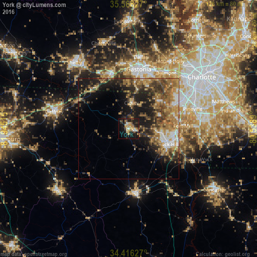
Analysis of York night lights 2016
Square area 10x10 km:
 1.22%
1.22%90-99
3.85%80-89
7.87%70-79
6.99%60-69
3.32%50-59
3.5%40-49
3.67%30-39
4.72%20-29
11.19%10-19
35.66%0-9
18.01%Square area 50x50 km:
1.96%90-99
2.46%80-89
3.61%70-79
4.01%60-69
5.05%50-59
4.19%40-49
4.37%30-39
5.23%20-29
5.98%10-19
12.25%0-9
50.89%Clear (daylight) street map image can be seen on geolist.org.
Map coordinates:
35° 34' 5.8" North, 81° 56' 42.5" West
34° 59' 39.5" North, 81° 14' 31.3" West
34° 24' 58.6" North, 80° 32' 20" West
Some cities around York sort by population:
• Gastonia
30.2 km =18.8 mi,  9°
9°
• Rock Hill
21.2 km =13.2 mi,  111°
111°
• Fort Mill
27.1 km =16.8 mi,  86°
86°
• Kings Mountain
29.3 km =18.2 mi,  342°
342°
• Tega Cay
19.8 km =12.3 mi,  80°
80°
• Lake Wylie
22.1 km =13.7 mi,  54°
54°
• Clover
13.1 km =8.1 mi, 6°
• South Gastonia
25.2 km =15.7 mi, 7°
4601703 (p: 8,009)
Sources (retrieved 2019-11-25):
» Earth at Night: Flat Maps 2012, 2016