Tega Cay night lights from space
Night Light of Tega Cay (South Carolina) from space (United States) Src. Average luminocity for 10x10km area is 65.1259% and for 50x50km: 51.3289%.
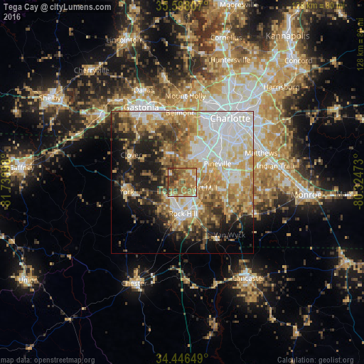
Analysis of Tega Cay night lights 2016
Square area 10x10 km:
 3.15%
3.15%90-99
7.17%80-89
10.49%70-79
15.91%60-69
30.07%50-59
12.94%40-49
9.62%30-39
10.49%20-29
0.17%10-19
0%0-9
0%Square area 50x50 km:
11.44%90-99
9.79%80-89
8.96%70-79
8.5%60-69
8.41%50-59
5.66%40-49
5.5%30-39
5.7%20-29
6.29%10-19
11.06%0-9
18.68%Clear (daylight) street map image can be seen on geolist.org.
Map coordinates:
35° 35' 53.1" North, 81° 43' 51.5" West
35° 1' 27.5" North, 81° 1' 40.3" West
34° 26' 47.4" North, 80° 19' 29" West
Some cities around Tega Cay sort by population:
• Rock Hill
11.1 km =6.9 mi,  178°
178°
• Fort Mill
7.8 km =4.8 mi,  104°
104°
• Weddington
24.3 km =15.1 mi,  90°
90°
• Lake Wylie
9.5 km =5.9 mi,  351°
351°
• Pineville
14 km =8.7 mi,  62°
62°
• York
19.8 km =12.3 mi,  260°
260°
• Marvin
19.7 km =12.2 mi, 100°
• Clover
20.5 km =12.7 mi,  298°
298°
4598379 (p: 9,608)
Sources (retrieved 2019-11-25):
» Earth at Night: Flat Maps 2012, 2016