Lake Wylie night lights from space
Night Light of Lake Wylie (South Carolina) from space (United States) Src. Average luminocity for 10x10km area is 62.7203% and for 50x50km: 62.1935%.
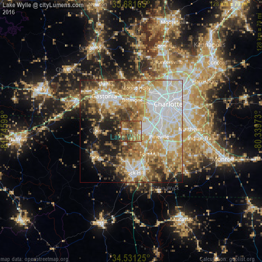
Analysis of Lake Wylie night lights 2016
Square area 10x10 km:
 4.55%
4.55%90-99
3.5%80-89
10.14%70-79
13.64%60-69
23.08%50-59
21.33%40-49
13.99%30-39
9.27%20-29
0.52%10-19
0%0-9
0%Square area 50x50 km:
15.05%90-99
12.82%80-89
11.38%70-79
10.49%60-69
9.79%50-59
6.22%40-49
6%30-39
5.7%20-29
5.79%10-19
9.1%0-9
7.66%Clear (daylight) street map image can be seen on geolist.org.
Map coordinates:
35° 40' 53.9" North, 81° 44' 45.5" West
35° 6' 30.5" North, 81° 2' 34.3" West
34° 31' 52.5" North, 80° 20' 23" West
Some cities around Lake Wylie sort by population:
• Rock Hill
20.5 km =12.7 mi,  175°
175°
• Mount Holly
21.2 km =13.2 mi,  6°
6°
• Fort Mill
14.3 km =8.9 mi,  141°
141°
• Belmont
15 km =9.3 mi,  1°
1°
• Tega Cay
9.5 km =5.9 mi,  171°
171°
• Pineville
14 km =8.7 mi,  101°
101°
• Clover
16.7 km =10.4 mi,  271°
271°
• South Gastonia
19.3 km =12 mi,  309°
309°
4584474 (p: 8,841)
Sources (retrieved 2019-11-25):
» Earth at Night: Flat Maps 2012, 2016