Fort Mill night lights from space
Night Light of Fort Mill (South Carolina) from space (United States) Src. Average luminocity for 10x10km area is 73.4108% and for 50x50km: 53.1272%.
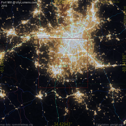
Analysis of Fort Mill night lights 2016
Square area 10x10 km:
 7.52%
7.52%90-99
9.27%80-89
14.86%70-79
20.8%60-69
35.31%50-59
9.09%40-49
2.45%30-39
0.7%20-29
0%10-19
0%0-9
0%Square area 50x50 km:
11.29%90-99
10.18%80-89
9.71%70-79
9.66%60-69
9.37%50-59
5.89%40-49
5.51%30-39
5.3%20-29
5.35%10-19
9.21%0-9
18.54%Clear (daylight) street map image can be seen on geolist.org.
Map coordinates:
35° 34' 52.5" North, 81° 38' 53.6" West
35° 0' 26.5" North, 80° 56' 42.3" West
34° 25' 45.9" North, 80° 14' 31.1" West
Some cities around Fort Mill sort by population:
• Rock Hill
11.7 km =7.3 mi,  218°
218°
• Matthews
23.5 km =14.6 mi,  58°
58°
• Waxhaw
20.6 km =12.8 mi,  116°
116°
• Weddington
16.9 km =10.5 mi,  84°
84°
• Tega Cay
7.8 km =4.8 mi,  284°
284°
• Lake Wylie
14.3 km =8.9 mi,  321°
321°
• Pineville
9.7 km =6 mi,  29°
29°
• Marvin
12 km =7.5 mi,  98°
98°
4578977 (p: 13,662)
Sources (retrieved 2019-11-25):
» Earth at Night: Flat Maps 2012, 2016