Clover night lights from space
Night Light of Clover (South Carolina) from space (United States) Src. Average luminocity for 10x10km area is 29.771% and for 50x50km: 40.2535%.
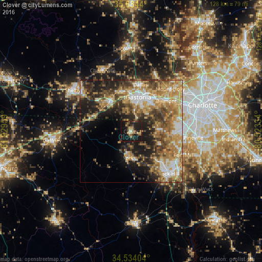
Analysis of Clover night lights 2016
Square area 10x10 km:
 0.35%
0.35%90-99
0.35%80-89
7.17%70-79
5.24%60-69
3.67%50-59
3.32%40-49
4.9%30-39
7.17%20-29
11.89%10-19
47.38%0-9
8.57%Square area 50x50 km:
4.97%90-99
5.57%80-89
7.65%70-79
7.79%60-69
8.22%50-59
5.74%40-49
6.28%30-39
6.59%20-29
8.09%10-19
12.58%0-9
26.51%Clear (daylight) street map image can be seen on geolist.org.
Map coordinates:
35° 41' 3.8" North, 81° 55' 46.5" West
35° 6' 40.5" North, 81° 13' 35.3" West
34° 32' 2.5" North, 80° 31' 24" West
Some cities around Clover sort by population:
• Gastonia
17.1 km =10.6 mi,  11°
11°
• Kings Mountain
18.2 km =11.3 mi,  324°
324°
• Belmont
22.6 km =14 mi,  49°
49°
• Tega Cay
20.5 km =12.7 mi,  118°
118°
• Lake Wylie
16.7 km =10.4 mi,  91°
91°
• York
13.1 km =8.1 mi,  186°
186°
• Bessemer City
20 km =12.4 mi,  344°
344°
• South Gastonia
12.2 km =7.6 mi, 8°
4575061 (p: 5,744)
Sources (retrieved 2019-11-25):
» Earth at Night: Flat Maps 2012, 2016