South Gastonia night lights from space
Night Light of South Gastonia (North Carolina) from space (United States) Src. Average luminocity for 10x10km area is 71.3776% and for 50x50km: 41.6967%.
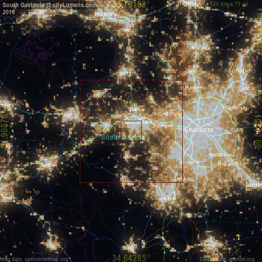
Analysis of South Gastonia night lights 2016
Square area 10x10 km:
 15.38%
90-99
16.08%80-89
11.01%70-79
12.24%60-69
12.59%50-59
9.44%40-49
9.44%30-39
9.27%20-29
4.02%10-19
0.52%0-9
0%Square area 50x50 km:
4.65%90-99
5.06%80-89
7.45%70-79
7.87%60-69
8.31%50-59
5.67%40-49
7.33%30-39
8.18%20-29
10.46%10-19
17.6%0-9
17.42%Clear (daylight) street map image can be seen on geolist.org.
Map coordinates:
35° 47' 30" North, 81° 54' 31.5" West
35° 13' 9.5" North, 81° 12' 20.3" West
34° 38' 34.3" North, 80° 30' 9" West
Some cities around South Gastonia sort by population:
• Gastonia
5 km =3.1 mi,  19°
19°
• Mount Holly
19.3 km =12 mi,  63°
63°
• Kings Mountain
12.6 km =7.8 mi,  283°
283°
• Belmont
15.5 km =9.6 mi,  80°
80°
• Lake Wylie
19.3 km =12 mi,  129°
129°
• Cherryville
23.7 km =14.7 mi,  318°
318°
• Clover
12.2 km =7.6 mi,  188°
188°
• Bessemer City
10.2 km =6.3 mi, 315°
4492573 (p: 5,312)
Sources (retrieved 2019-11-25):
» Earth at Night: Flat Maps 2012, 2016