Yoakum night lights from space
Night Light of Yoakum (Texas) from space (United States) Src. Average luminocity for 10x10km area is 16.2519% and for 50x50km: 6.0563%.
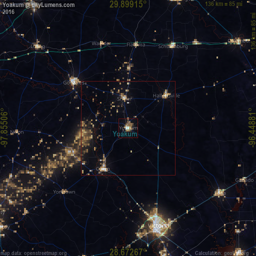
Analysis of Yoakum night lights 2016
Square area 10x10 km:
 1.14%
1.14%90-99
1.89%80-89
0.57%70-79
1.89%60-69
2.65%50-59
5.68%40-49
3.22%30-39
0.95%20-29
4.36%10-19
1.89%0-9
75.76%Square area 50x50 km:
0.22%90-99
0.25%80-89
0.79%70-79
0.94%60-69
0.87%50-59
1.05%40-49
1.24%30-39
1.67%20-29
1.49%10-19
2.84%0-9
88.62%Clear (daylight) street map image can be seen on geolist.org.
Map coordinates:
29° 53' 56.9" North, 97° 51' 18.2" West
29° 17' 15.9" North, 97° 9' 6.9" West
28° 40' 21.6" North, 96° 26' 55.7" West
Some cities around Yoakum sort by population:
• Victoria
55.6 km =34.5 mi,  164°
164°
• Seguin
84.7 km =52.6 mi,  291°
291°
• Lockhart
83.2 km =51.7 mi,  322°
322°
• El Campo
86.2 km =53.6 mi,  96°
96°
• Gonzales
37.6 km =23.4 mi,  309°
309°
• Cuero
25.3 km =15.7 mi,  211°
211°
• Edna
60 km =37.3 mi,  124°
124°
• Luling
64.9 km =40.3 mi, 312°
4743432 (p: 6,016)
Sources (retrieved 2019-11-25):
» Earth at Night: Flat Maps 2012, 2016