Lockhart night lights from space
Night Light of Lockhart (Texas) from space (United States) Src. Average luminocity for 10x10km area is 29.6131% and for 50x50km: 10.2319%.
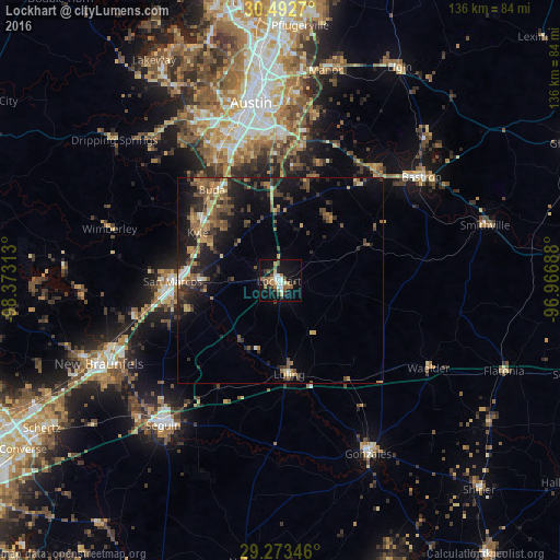
Analysis of Lockhart night lights 2016
Square area 10x10 km:
 3.37%
3.37%90-99
5.36%80-89
2.38%70-79
2.58%60-69
5.56%50-59
5.95%40-49
5.16%30-39
3.17%20-29
4.76%10-19
29.17%0-9
32.54%Square area 50x50 km:
0.57%90-99
0.67%80-89
0.96%70-79
1.29%60-69
1.89%50-59
2.07%40-49
2.55%30-39
2.08%20-29
3.55%10-19
7.96%0-9
76.41%Clear (daylight) street map image can be seen on geolist.org.
Map coordinates:
30° 29' 33.7" North, 98° 22' 23.3" West
29° 53' 5.8" North, 97° 40' 12" West
29° 16' 24.5" North, 96° 58' 0.8" West
Some cities around Lockhart sort by population:
• Austin
43.1 km =26.8 mi,  350°
350°
• San Marcos
26.2 km =16.3 mi,  269°
269°
• Kyle
23.1 km =14.4 mi,  300°
300°
• Buda
27.7 km =17.2 mi,  323°
323°
• Bastrop
42.4 km =26.3 mi,  53°
53°
• Hornsby Bend
41.2 km =25.6 mi,  11°
11°
• Luling
22.8 km =14.2 mi,  174°
174°
• Shady Hollow
36.2 km =22.5 mi,  329°
329°
4707295 (p: 13,446)
Sources (retrieved 2019-11-25):
» Earth at Night: Flat Maps 2012, 2016