Seguin night lights from space
Night Light of Seguin (Texas) from space (United States) Src. Average luminocity for 10x10km area is 51.1913% and for 50x50km: 10.8203%.
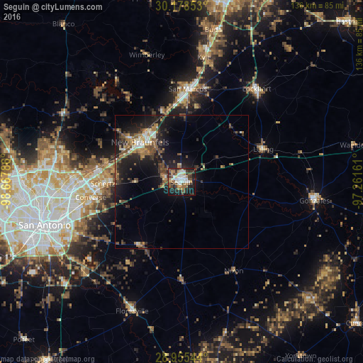

Analysis of Seguin night lights 2016
Square area 10x10 km:
 10.23%
90-99
10.61%80-89
2.65%70-79
5.11%60-69
9.28%50-59
7.2%40-49
11.74%30-39
9.09%20-29
13.64%10-19
19.7%0-9
0.76%Square area 50x50 km:
1.06%90-99
1.2%80-89
0.75%70-79
1.19%60-69
1.66%50-59
2.3%40-49
2.31%30-39
2.1%20-29
3.89%10-19
9.09%0-9
74.44%Clear (daylight) street map image can be seen on geolist.org.
Map coordinates:
30° 10' 42.7" North, 98° 40' 4.3" West
29° 34' 7.8" North, 97° 57' 53" West
28° 57' 19.6" North, 97° 15' 41.8" West
Some cities around Seguin sort by population:
• New Braunfels
21.5 km =13.4 mi,  314°
314°
• San Marcos
35 km =21.7 mi,  3°
3°
• Schertz
29.6 km =18.4 mi,  266°
266°
• Cibolo
25.4 km =15.8 mi, 268°
• Converse
34.5 km =21.4 mi,  260°
260°
• Universal City
31.7 km =19.7 mi, 265°
• Selma
33 km =20.5 mi, 273°
• Luling
33.1 km =20.6 mi,  67°
67°
4727756 (p: 27,864)
Sources (retrieved 2019-11-25):
» Earth at Night: Flat Maps 2012, 2016