New Milford night lights from space
Night Light of New Milford (Connecticut) from space (United States) Src. Average luminocity for 10x10km area is 14% and for 50x50km: 10.6737%.
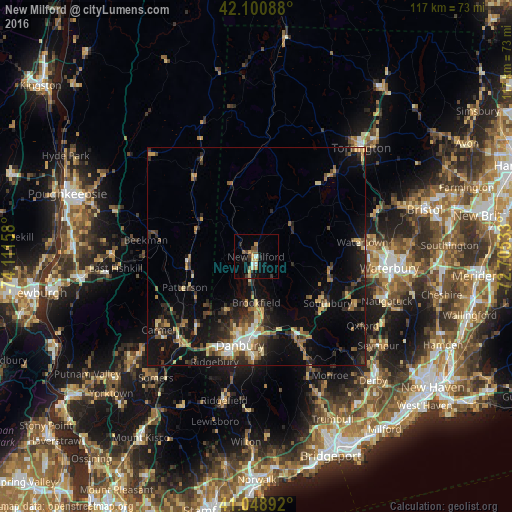
Analysis of New Milford night lights 2016
Square area 10x10 km:
 1.14%
1.14%90-99
1.14%80-89
2.44%70-79
3.08%60-69
0.97%50-59
1.62%40-49
2.27%30-39
1.62%20-29
3.25%10-19
5.19%0-9
77.27%Square area 50x50 km:
0.71%90-99
0.91%80-89
1.54%70-79
1.49%60-69
1.51%50-59
1.23%40-49
1.92%30-39
1.9%20-29
3.85%10-19
9.62%0-9
75.33%Clear (daylight) street map image can be seen on geolist.org.
Map coordinates:
42° 6' 3.2" North, 74° 6' 41.7" West
41° 34' 37.3" North, 73° 24' 30.4" West
41° 2' 56.1" North, 72° 42' 19.2" West
Some cities around New Milford sort by population:
• Danbury
20.6 km =12.8 mi,  190°
190°
• Southbury
19.4 km =12.1 mi,  123°
123°
• New Fairfield
13.9 km =8.6 mi,  207°
207°
• Woodbury
17 km =10.6 mi,  102°
102°
• Bethel
22.9 km =14.2 mi,  181°
181°
• Oakville
26.9 km =16.7 mi,  86°
86°
• Lake Carmel
25.4 km =15.8 mi,  239°
239°
• Middlebury
24 km =14.9 mi, 103°
4839435 (p: 6,523)
Sources (retrieved 2019-11-25):
» Earth at Night: Flat Maps 2012, 2016