Woodbridge night lights from space
Night Light of Woodbridge (New Jersey) from space (United States) Src. Average luminocity for 10x10km area is 96.4432% and for 50x50km: 71.9077%.
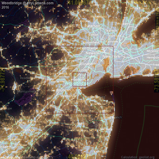
Analysis of Woodbridge night lights 2016
Square area 10x10 km:
 47.4%
47.4%90-99
36.85%80-89
12.34%70-79
3.08%60-69
0.32%50-59
0%40-49
0%30-39
0%20-29
0%10-19
0%0-9
0%Square area 50x50 km:
23.99%90-99
16.24%80-89
8.23%70-79
9.92%60-69
10.51%50-59
9.68%40-49
5.5%30-39
4.37%20-29
4.45%10-19
3.92%0-9
3.2%Clear (daylight) street map image can be seen on geolist.org.
Map coordinates:
41° 5' 22.8" North, 74° 59' 15.8" West
40° 33' 27.4" North, 74° 17' 4.5" West
40° 1' 16.6" North, 73° 34' 53.3" West
Some cities around Woodbridge sort by population:
• Perth Amboy
5.9 km =3.7 mi,  164°
164°
• Rahway
5.7 km =3.5 mi,  5°
5°
• Carteret
5.2 km =3.2 mi,  65°
65°
• Rossville
6 km =3.7 mi,  92°
92°
• Iselin
3.8 km =2.4 mi,  301°
301°
• Colonia
2.4 km =1.5 mi,  321°
321°
• Avenel
2.5 km =1.6 mi,  358°
358°
• Fords
4.1 km =2.5 mi,  220°
220°
5106529 (p: 19,265)
Sources (retrieved 2019-11-25):
» Earth at Night: Flat Maps 2012, 2016