Fords night lights from space
Night Light of Fords (New Jersey) from space (United States) Src. Average luminocity for 10x10km area is 93.3827% and for 50x50km: 70.3669%.
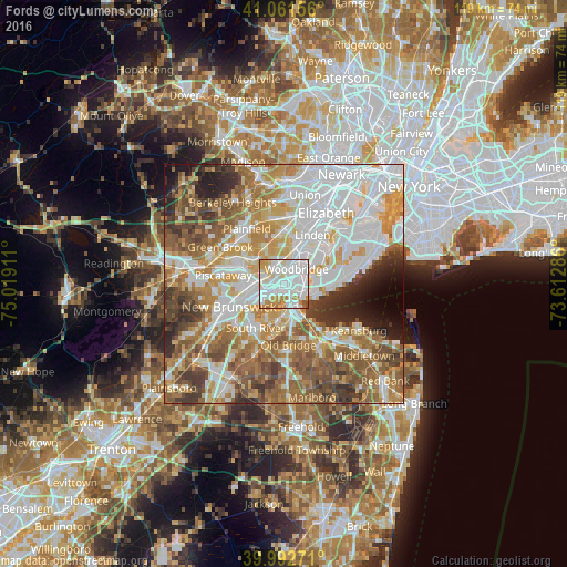
Analysis of Fords night lights 2016
Square area 10x10 km:
 44.9%
44.9%90-99
30.78%80-89
9.01%70-79
8.84%60-69
5.1%50-59
0.51%40-49
0.85%30-39
0%20-29
0%10-19
0%0-9
0%Square area 50x50 km:
20.85%90-99
15.19%80-89
8.27%70-79
10.18%60-69
11.5%50-59
11.07%40-49
6.62%30-39
5.97%20-29
4.9%10-19
3.28%0-9
2.18%Clear (daylight) street map image can be seen on geolist.org.
Map coordinates:
41° 3' 41.6" North, 75° 1' 8.8" West
40° 31' 45.4" North, 74° 18' 57.5" West
39° 59' 33.8" North, 73° 36' 46.3" West
Some cities around Fords sort by population:
• Perth Amboy
5 km =3.1 mi,  120°
120°
• Sayreville Junction
7.2 km =4.5 mi,  189°
189°
• Woodbridge
4.1 km =2.5 mi,  40°
40°
• Iselin
5.2 km =3.2 mi,  353°
353°
• Colonia
5.2 km =3.2 mi,  13°
13°
• Avenel
6.3 km =3.9 mi,  24°
24°
• Metuchen
4.3 km =2.7 mi,  291°
291°
• South Amboy
6.1 km =3.8 mi,  159°
159°
5098109 (p: 15,187)
Sources (retrieved 2019-11-25):
» Earth at Night: Flat Maps 2012, 2016