Willoughby night lights from space
Night Light of Willoughby (Ohio) from space (United States) Src. Average luminocity for 10x10km area is 74.9286% and for 50x50km: 30.8047%.

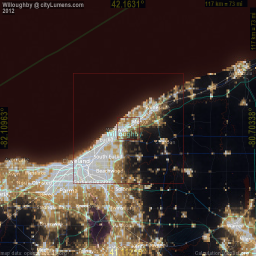
Analysis of Willoughby night lights 2016
Square area 10x10 km:
 18.99%
90-99
25.16%80-89
10.88%70-79
7.63%60-69
10.88%50-59
4.22%40-49
5.03%30-39
8.93%20-29
7.79%10-19
0.49%0-9
0%Square area 50x50 km:
10.9%90-99
7.14%80-89
2.14%70-79
2.16%60-69
2.64%50-59
2.79%40-49
3.2%30-39
3.49%20-29
6.12%10-19
9.72%0-9
49.7%Clear (daylight) street map image can be seen on geolist.org.
Map coordinates:
42° 9' 47.2" North, 82° 6' 34.7" West
41° 38' 23.2" North, 81° 24' 23.4" West
41° 6' 43.8" North, 80° 42' 12.2" West
Some cities around Willoughby sort by population:
• Euclid
11.3 km =7 mi,  242°
242°
• Mentor
6.3 km =3.9 mi,  62°
62°
• Eastlake
4 km =2.5 mi,  293°
293°
• Wickliffe
5.5 km =3.4 mi,  225°
225°
• Richmond Heights
12.9 km =8 mi,  221°
221°
• Highland Heights
11.4 km =7.1 mi,  211°
211°
• Mentor-on-the-Lake
8.2 km =5.1 mi,  27°
27°
• Kirtland
3.9 km =2.4 mi,  107°
107°
5176937 (p: 22,631)
Sources (retrieved 2019-11-25):
» Earth at Night: Flat Maps 2012, 2016