Weston night lights from space
Night Light of Weston (Massachusetts) from space (United States) Src. Average luminocity for 10x10km area is 51.5778% and for 50x50km: 54.4348%.
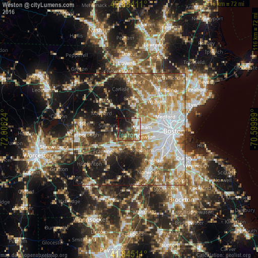
Analysis of Weston night lights 2016
Square area 10x10 km:
 8.73%
8.73%90-99
10.95%80-89
5.4%70-79
4.92%60-69
6.67%50-59
7.94%40-49
14.92%30-39
10.95%20-29
11.9%10-19
13.65%0-9
3.97%Square area 50x50 km:
12.34%90-99
10.75%80-89
6.23%70-79
7.02%60-69
9.38%50-59
9.88%40-49
6.78%30-39
4.98%20-29
8.78%10-19
18.35%0-9
5.52%Clear (daylight) street map image can be seen on geolist.org.
Map coordinates:
42° 53' 2.8" North, 72° 0' 22.5" West
42° 22' 0.3" North, 71° 18' 11.2" West
41° 50' 42.4" North, 70° 35' 60" West
Some cities around Weston sort by population:
• Newton
8.4 km =5.2 mi,  113°
113°
• Waltham
5.6 km =3.5 mi,  78°
78°
• Watertown
9.9 km =6.2 mi,  87°
87°
• Wellesley
7.9 km =4.9 mi,  173°
173°
• Sudbury
9.5 km =5.9 mi,  281°
281°
• Wayland
4.8 km =3 mi,  264°
264°
• Lincoln
6.6 km =4.1 mi,  359°
359°
• Cochituate
7.2 km =4.5 mi,  224°
224°
4955259 (p: 11,682)
Sources (retrieved 2019-11-25):
» Earth at Night: Flat Maps 2012, 2016