Lincoln night lights from space
Night Light of Lincoln (Massachusetts) from space (United States) Src. Average luminocity for 10x10km area is 38.4333% and for 50x50km: 53.7102%.
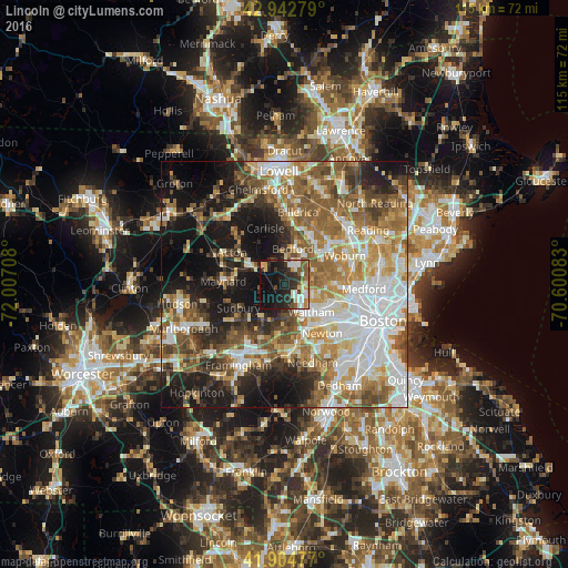
Analysis of Lincoln night lights 2016
Square area 10x10 km:
 5.24%
5.24%90-99
8.73%80-89
4.13%70-79
4.6%60-69
1.75%50-59
7.3%40-49
3.02%30-39
9.21%20-29
15.56%10-19
26.35%0-9
14.13%Square area 50x50 km:
12.29%90-99
10.41%80-89
6.39%70-79
6.79%60-69
8.85%50-59
9.83%40-49
6.94%30-39
5.4%20-29
8.72%10-19
16.76%0-9
7.62%Clear (daylight) street map image can be seen on geolist.org.
Map coordinates:
42° 56' 34" North, 72° 0' 25.5" West
42° 25' 33.3" North, 71° 18' 14.2" West
41° 54' 17.2" North, 70° 36' 3" West
Some cities around Lincoln sort by population:
• Waltham
7.9 km =4.9 mi,  134°
134°
• Lexington
6.9 km =4.3 mi,  69°
69°
• Sudbury
10.4 km =6.5 mi,  242°
242°
• Concord
5.3 km =3.3 mi,  316°
316°
• Wayland
8.5 km =5.3 mi,  213°
213°
• Bedford
7.5 km =4.7 mi,  17°
17°
• Weston
6.6 km =4.1 mi,  179°
179°
• West Concord
8.3 km =5.2 mi,  295°
295°
4942021 (p: 8,197)
Sources (retrieved 2019-11-25):
» Earth at Night: Flat Maps 2012, 2016