Sudbury night lights from space
Night Light of Sudbury (Massachusetts) from space (United States) Src. Average luminocity for 10x10km area is 24.4143% and for 50x50km: 44.596%.
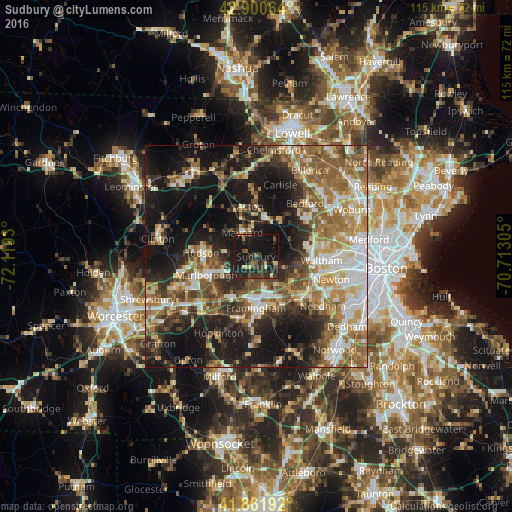
Analysis of Sudbury night lights 2016
Square area 10x10 km:
 0%
0%90-99
0.32%80-89
4.76%70-79
0.63%60-69
1.11%50-59
3.81%40-49
5.4%30-39
7.94%20-29
18.57%10-19
48.73%0-9
8.73%Square area 50x50 km:
6.79%90-99
7.55%80-89
5.67%70-79
5.43%60-69
7.84%50-59
9.39%40-49
6.41%30-39
5.93%20-29
10.97%10-19
24.04%0-9
9.99%Clear (daylight) street map image can be seen on geolist.org.
Map coordinates:
42° 54' 2.3" North, 72° 7' 9.5" West
42° 23' 0.3" North, 71° 24' 58.2" West
41° 51' 42.9" North, 70° 42' 47" West
Some cities around Sudbury sort by population:
• Framingham Center
9.7 km =6 mi,  190°
190°
• Concord
10.2 km =6.3 mi,  32°
32°
• Wayland
5.1 km =3.2 mi,  117°
117°
• Weston
9.5 km =5.9 mi,  101°
101°
• Maynard
6.2 km =3.9 mi,  333°
333°
• Cochituate
8.2 km =5.1 mi,  148°
148°
• West Concord
8.5 km =5.3 mi,  11°
11°
• Stow
9.5 km =5.9 mi,  309°
309°
4952320 (p: 17,343)
Sources (retrieved 2019-11-25):
» Earth at Night: Flat Maps 2012, 2016