West View night lights from space
Night Light of West View (Pennsylvania) from space (United States) Src. Average luminocity for 10x10km area is 74.6412% and for 50x50km: 52.714%.
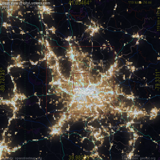
Analysis of West View night lights 2016
Square area 10x10 km:
 10.2%
10.2%90-99
11.22%80-89
10.03%70-79
25.85%60-69
24.32%50-59
17.35%40-49
1.02%30-39
0%20-29
0%10-19
0%0-9
0%Square area 50x50 km:
8.61%90-99
9.94%80-89
6.11%70-79
7.67%60-69
10.81%50-59
11.76%40-49
9.44%30-39
6.35%20-29
8.21%10-19
9.69%0-9
11.42%Clear (daylight) street map image can be seen on geolist.org.
Map coordinates:
41° 3' 16.7" North, 80° 44' 14.5" West
40° 31' 20.2" North, 80° 2' 3.2" West
39° 59' 8.4" North, 79° 19' 52" West
Some cities around West View sort by population:
• Pittsburgh
9.6 km =6 mi,  160°
160°
• Allison Park
7.6 km =4.7 mi,  57°
57°
• Franklin Park
8.2 km =5.1 mi,  326°
326°
• Glenshaw
5.8 km =3.6 mi,  78°
78°
• Bellevue
3.5 km =2.2 mi,  205°
205°
• McKees Rocks
6.8 km =4.2 mi,  202°
202°
• Crafton
10.1 km =6.3 mi, 195°
• Coraopolis
11.2 km =7 mi,  267°
267°
5218918 (p: 6,685)
Sources (retrieved 2019-11-25):
» Earth at Night: Flat Maps 2012, 2016