Bellevue night lights from space
Night Light of Bellevue (Pennsylvania) from space (United States) Src. Average luminocity for 10x10km area is 84.1122% and for 50x50km: 53.2689%.
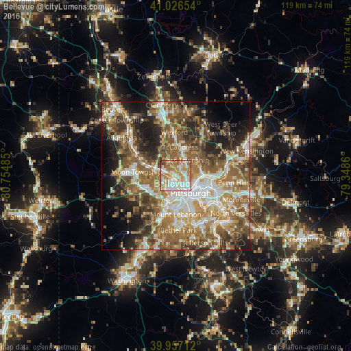
Analysis of Bellevue night lights 2016
Square area 10x10 km:
 26.02%
90-99
20.92%80-89
10.88%70-79
19.22%60-69
17.35%50-59
3.23%40-49
1.7%30-39
0.68%20-29
0%10-19
0%0-9
0%Square area 50x50 km:
8.74%90-99
10.09%80-89
6.15%70-79
7.68%60-69
11.03%50-59
12.2%40-49
9.4%30-39
6.18%20-29
8.37%10-19
9.26%0-9
10.91%Clear (daylight) street map image can be seen on geolist.org.
Map coordinates:
41° 1' 35.5" North, 80° 45' 17.5" West
40° 29' 38.3" North, 80° 3' 6.2" West
39° 57' 25.6" North, 79° 20' 55" West
Some cities around Bellevue sort by population:
• Pittsburgh
7.6 km =4.7 mi,  141°
141°
• Franklin Park
10.4 km =6.5 mi,  342°
342°
• Glenshaw
8.3 km =5.2 mi,  58°
58°
• Carnegie
9.9 km =6.2 mi,  195°
195°
• West View
3.5 km =2.2 mi,  25°
25°
• McKees Rocks
3.4 km =2.1 mi, 200°
• Crafton
6.7 km =4.2 mi,  190°
190°
• Coraopolis
10.1 km =6.3 mi,  285°
285°
5179811 (p: 8,252)
Sources (retrieved 2019-11-25):
» Earth at Night: Flat Maps 2012, 2016