Coatesville night lights from space
Night Light of Coatesville (Pennsylvania) from space (United States) Src. Average luminocity for 10x10km area is 45.3827% and for 50x50km: 26.7759%.
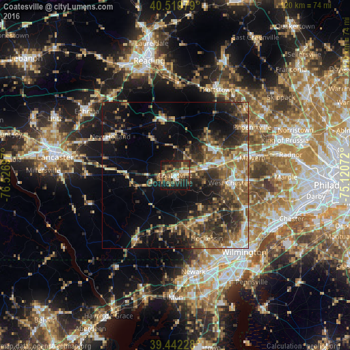
Analysis of Coatesville night lights 2016
Square area 10x10 km:
 5.61%
5.61%90-99
4.42%80-89
5.61%70-79
6.29%60-69
8.67%50-59
9.52%40-49
8.67%30-39
14.63%20-29
11.39%10-19
24.83%0-9
0.34%Square area 50x50 km:
2.49%90-99
2.4%80-89
3.82%70-79
3.62%60-69
4.86%50-59
5.76%40-49
4.8%30-39
6.86%20-29
7.65%10-19
14.07%0-9
43.66%Clear (daylight) street map image can be seen on geolist.org.
Map coordinates:
40° 31' 11.2" North, 76° 31' 37.1" West
39° 58' 59.4" North, 75° 49' 25.8" West
39° 26' 32.2" North, 75° 7' 14.6" West
Some cities around Coatesville sort by population:
• West Chester
18.6 km =11.6 mi,  97°
97°
• Hockessin
24.3 km =15.1 mi,  153°
153°
• Downingtown
10.6 km =6.6 mi,  75°
75°
• Chester Springs
21.6 km =13.4 mi,  54°
54°
• Lionville
16 km =9.9 mi,  60°
60°
• Kennett Square
17.9 km =11.1 mi, 147°
• New Holland
25.9 km =16.1 mi,  300°
300°
• Oxford
25.7 km =16 mi,  211°
211°
4557247 (p: 13,148)
Sources (retrieved 2019-11-25):
» Earth at Night: Flat Maps 2012, 2016