Village Green-Green Ridge night lights from space
Night Light of Village Green-Green Ridge (Pennsylvania) from space (United States) Src. Average luminocity for 10x10km area is 81.3282% and for 50x50km: 65.7748%.
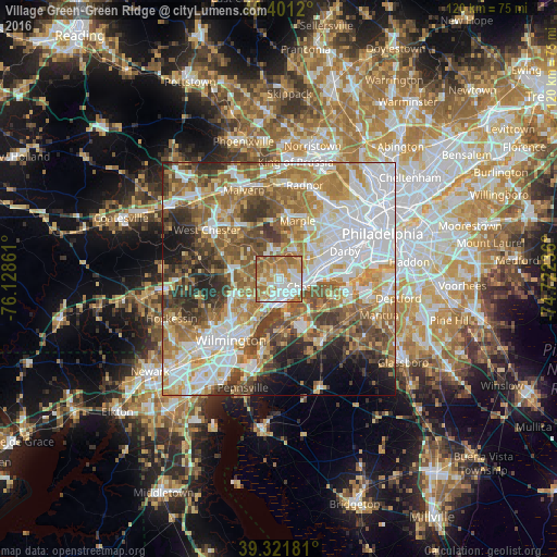
Analysis of Village Green-Green Ridge night lights 2016
Square area 10x10 km:
 16.84%
90-99
23.64%80-89
9.01%70-79
20.24%60-69
24.49%50-59
5.61%40-49
0.17%30-39
0%20-29
0%10-19
0%0-9
0%Square area 50x50 km:
17.68%90-99
12.76%80-89
7.98%70-79
10.07%60-69
12.07%50-59
10.29%40-49
7.78%30-39
6.97%20-29
5.45%10-19
5%0-9
3.95%Clear (daylight) street map image can be seen on geolist.org.
Map coordinates:
40° 24' 4.3" North, 76° 7' 43" West
39° 51' 49.1" North, 75° 25' 31.7" West
39° 19' 18.5" North, 74° 43' 20.5" West
Some cities around Village Green-Green Ridge sort by population:
• Chester
6 km =3.7 mi,  104°
104°
• Woodlyn
7.6 km =4.7 mi,  82°
82°
• Folsom
9 km =5.6 mi,  71°
71°
• Claymont
7.6 km =4.7 mi,  202°
202°
• Brookhaven
3.7 km =2.3 mi, 80°
• Ridley Park
8.9 km =5.5 mi, 77°
• Swarthmore
7.7 km =4.8 mi,  56°
56°
• Media
6.7 km =4.2 mi,  28°
28°
7259124 (p: 7,822)
Sources (retrieved 2019-11-25):
» Earth at Night: Flat Maps 2012, 2016