Media night lights from space
Night Light of Media (Pennsylvania) from space (United States) Src. Average luminocity for 10x10km area is 74.7602% and for 50x50km: 71.0748%.
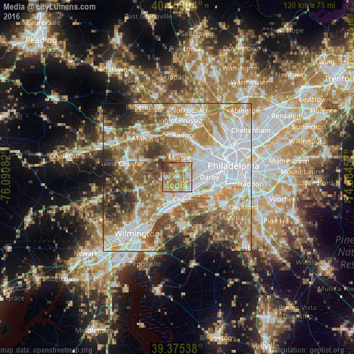
Analysis of Media night lights 2016
Square area 10x10 km:
 9.86%
9.86%90-99
11.9%80-89
15.31%70-79
24.83%60-69
23.64%50-59
7.82%40-49
2.21%30-39
4.42%20-29
0%10-19
0%0-9
0%Square area 50x50 km:
20.41%90-99
13.87%80-89
9%70-79
11.47%60-69
13.11%50-59
10.15%40-49
7.32%30-39
6.09%20-29
5%10-19
3.14%0-9
0.44%Clear (daylight) street map image can be seen on geolist.org.
Map coordinates:
40° 27' 14.2" North, 76° 5' 27" West
39° 55' 0.4" North, 75° 23' 15.7" West
39° 22' 31.4" North, 74° 41' 4.5" West
Some cities around Media sort by population:
• Springfield
6 km =3.7 mi,  74°
74°
• Woodlyn
6.6 km =4.1 mi,  138°
138°
• Folsom
6.1 km =3.8 mi,  119°
119°
• Brookhaven
5.3 km =3.3 mi,  175°
175°
• Village Green-Green Ridge
6.7 km =4.2 mi,  208°
208°
• Ridley Park
6.7 km =4.2 mi,  125°
125°
• Prospect Park
7.5 km =4.7 mi, 115°
• Swarthmore
3.6 km =2.2 mi, 116°
4559575 (p: 5,363)
Sources (retrieved 2019-11-25):
» Earth at Night: Flat Maps 2012, 2016