West Boylston night lights from space
Night Light of West Boylston (Massachusetts) from space (United States) Src. Average luminocity for 10x10km area is 31.2556% and for 50x50km: 27.0995%.
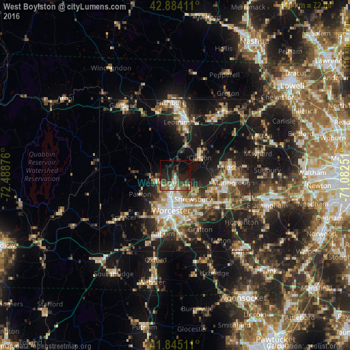
Analysis of West Boylston night lights 2016
Square area 10x10 km:
 1.75%
1.75%90-99
3.97%80-89
3.17%70-79
2.06%60-69
5.24%50-59
5.4%40-49
9.37%30-39
7.14%20-29
15.08%10-19
24.44%0-9
22.38%Square area 50x50 km:
3.25%90-99
4.25%80-89
3.21%70-79
3.15%60-69
4.1%50-59
4.73%40-49
4.28%30-39
4.6%20-29
8.9%10-19
18.65%0-9
40.88%Clear (daylight) street map image can be seen on geolist.org.
Map coordinates:
42° 53' 2.8" North, 72° 29' 19.5" West
42° 22' 0.3" North, 71° 47' 8.3" West
41° 50' 42.4" North, 71° 4' 57" West
Some cities around West Boylston sort by population:
• Worcester
11.7 km =7.3 mi,  186°
186°
• Shrewsbury
9.9 km =6.2 mi,  142°
142°
• Holden
6.6 km =4.1 mi,  255°
255°
• Hamilton Worcester
12.4 km =7.7 mi,  173°
173°
• Lancaster
13.5 km =8.4 mi,  43°
43°
• Clinton
10.1 km =6.3 mi,  56°
56°
• Sterling
8.1 km =5 mi,  14°
14°
• Northborough
13 km =8.1 mi,  113°
113°
4954850 (p: 7,612)
Sources (retrieved 2019-11-25):
» Earth at Night: Flat Maps 2012, 2016