Clinton night lights from space
Night Light of Clinton (Massachusetts) from space (United States) Src. Average luminocity for 10x10km area is 20.5698% and for 50x50km: 30.6092%.
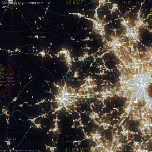
Analysis of Clinton night lights 2016
Square area 10x10 km:
 0.79%
0.79%90-99
1.27%80-89
3.33%70-79
3.49%60-69
0.79%50-59
1.9%40-49
2.86%30-39
2.06%20-29
8.25%10-19
41.75%0-9
33.49%Square area 50x50 km:
3.6%90-99
4.62%80-89
3.7%70-79
3.41%60-69
4.37%50-59
5.33%40-49
5.58%30-39
5.47%20-29
10.2%10-19
22.8%0-9
30.92%Clear (daylight) street map image can be seen on geolist.org.
Map coordinates:
42° 56' 1.3" North, 72° 23' 9.5" West
42° 25' 0.3" North, 71° 40' 58.3" West
41° 53' 43.9" North, 70° 58' 47" West
Some cities around Clinton sort by population:
• Leominster
13.6 km =8.5 mi,  332°
332°
• Marlborough
13.3 km =8.3 mi,  126°
126°
• Hudson
10 km =6.2 mi,  106°
106°
• West Boylston
10.1 km =6.3 mi,  236°
236°
• Lancaster
4.4 km =2.7 mi,  10°
10°
• Sterling
6.8 km =4.2 mi,  289°
289°
• Northborough
11.3 km =7 mi,  162°
162°
• Harvard
12.4 km =7.7 mi,  41°
41°
4933426 (p: 7,389)
Sources (retrieved 2019-11-25):
» Earth at Night: Flat Maps 2012, 2016