Holden night lights from space
Night Light of Holden (Massachusetts) from space (United States) Src. Average luminocity for 10x10km area is 26.8968% and for 50x50km: 22.6182%.
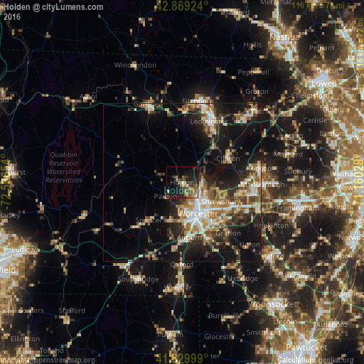
Analysis of Holden night lights 2016
Square area 10x10 km:
 1.27%
1.27%90-99
2.22%80-89
2.7%70-79
3.33%60-69
6.19%50-59
4.76%40-49
6.67%30-39
4.44%20-29
13.65%10-19
21.43%0-9
33.33%Square area 50x50 km:
2.9%90-99
3.62%80-89
2.78%70-79
2.73%60-69
3.46%50-59
3.66%40-49
3.22%30-39
3.49%20-29
6.98%10-19
14.98%0-9
52.19%Clear (daylight) street map image can be seen on geolist.org.
Map coordinates:
42° 52' 9.3" North, 72° 33' 59.5" West
42° 21' 6.3" North, 71° 51' 48.3" West
41° 49' 48" North, 71° 9' 37" West
Some cities around Holden sort by population:
• Worcester
11.1 km =6.9 mi,  153°
153°
• Shrewsbury
13.8 km =8.6 mi,  116°
116°
• Leicester
12.3 km =7.6 mi,  197°
197°
• Hamilton Worcester
13.2 km =8.2 mi,  143°
143°
• West Boylston
6.6 km =4.1 mi,  75°
75°
• Clinton
16.5 km =10.3 mi,  64°
64°
• Sterling
12.7 km =7.9 mi,  41°
41°
• Spencer
16 km =9.9 mi,  221°
221°
4939647 (p: 17,016)
Sources (retrieved 2019-11-25):
» Earth at Night: Flat Maps 2012, 2016