Northborough night lights from space
Night Light of Northborough (Massachusetts) from space (United States) Src. Average luminocity for 10x10km area is 58.9909% and for 50x50km: 32.3624%.
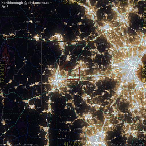
Analysis of Northborough night lights 2016
Square area 10x10 km:
 8.33%
8.33%90-99
12.27%80-89
9.55%70-79
8.03%60-69
9.55%50-59
9.85%40-49
11.82%30-39
11.67%20-29
10.76%10-19
8.18%0-9
0%Square area 50x50 km:
3.56%90-99
4.71%80-89
3.91%70-79
3.59%60-69
4.37%50-59
5.49%40-49
5.96%30-39
6.34%20-29
12.08%10-19
26.45%0-9
23.55%Clear (daylight) street map image can be seen on geolist.org.
Map coordinates:
42° 50' 14.2" North, 72° 20' 39.5" West
42° 19' 10.3" North, 71° 38' 28.2" West
41° 47' 51" North, 70° 56' 17" West
Some cities around Northborough sort by population:
• Marlborough
7.9 km =4.9 mi,  68°
68°
• Shrewsbury
6.5 km =4 mi,  245°
245°
• Grafton
13 km =8.1 mi,  196°
196°
• Hudson
10.1 km =6.3 mi,  37°
37°
• Southborough
9.7 km =6 mi,  99°
99°
• Hamilton Worcester
12.6 km =7.8 mi,  235°
235°
• West Boylston
13 km =8.1 mi,  293°
293°
• Clinton
11.3 km =7 mi,  342°
342°
4945840 (p: 6,167)
Sources (retrieved 2019-11-25):
» Earth at Night: Flat Maps 2012, 2016