Sterling night lights from space
Night Light of Sterling (Massachusetts) from space (United States) Src. Average luminocity for 10x10km area is 13.3397% and for 50x50km: 25.401%.
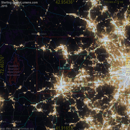
Analysis of Sterling night lights 2016
Square area 10x10 km:
 0%
0%90-99
0.63%80-89
0%70-79
1.11%60-69
0.32%50-59
3.33%40-49
2.86%30-39
2.86%20-29
5.24%10-19
28.25%0-9
55.4%Square area 50x50 km:
3.03%90-99
3.95%80-89
2.99%70-79
2.98%60-69
3.79%50-59
4.35%40-49
4.24%30-39
4.03%20-29
7.93%10-19
17.92%0-9
44.81%Clear (daylight) street map image can be seen on geolist.org.
Map coordinates:
42° 57' 15.7" North, 72° 27' 49.5" West
42° 26' 15.3" North, 71° 45' 38.3" West
41° 54' 59.5" North, 71° 3' 27" West
Some cities around Sterling sort by population:
• Leominster
9.7 km =6 mi,  0°
0°
• Shrewsbury
16.2 km =10.1 mi,  166°
166°
• Holden
12.7 km =7.9 mi,  221°
221°
• West Boylston
8.1 km =5 mi,  194°
194°
• Lancaster
7.5 km =4.7 mi,  74°
74°
• Clinton
6.8 km =4.2 mi,  109°
109°
• Northborough
16.4 km =10.2 mi,  143°
143°
• Harvard
16.2 km =10.1 mi,  64°
64°
4952005 (p: 7,384)
Sources (retrieved 2019-11-25):
» Earth at Night: Flat Maps 2012, 2016