Shrewsbury night lights from space
Night Light of Shrewsbury (Massachusetts) from space (United States) Src. Average luminocity for 10x10km area is 67.4121% and for 50x50km: 29.4442%.
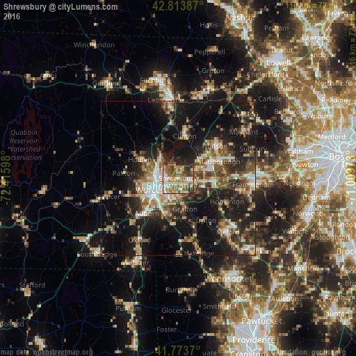

Analysis of Shrewsbury night lights 2016
Square area 10x10 km:
 10.45%
90-99
14.09%80-89
9.24%70-79
9.7%60-69
20.61%50-59
12.73%40-49
6.67%30-39
10%20-29
6.52%10-19
0%0-9
0%Square area 50x50 km:
3.05%90-99
4.22%80-89
3.75%70-79
3.46%60-69
4.24%50-59
4.96%40-49
5.33%30-39
5.66%20-29
10.54%10-19
21.9%0-9
32.89%Clear (daylight) street map image can be seen on geolist.org.
Map coordinates:
42° 48' 49.9" North, 72° 24' 57.5" West
42° 17' 45.3" North, 71° 42' 46.3" West
41° 46' 25.3" North, 71° 0' 35" West
Some cities around Shrewsbury sort by population:
• Worcester
8.2 km =5.1 mi,  243°
243°
• Holden
13.8 km =8.6 mi,  296°
296°
• Grafton
10.1 km =6.3 mi,  167°
167°
• Millbury
12 km =7.5 mi,  198°
198°
• Hamilton Worcester
6.3 km =3.9 mi,  225°
225°
• West Boylston
9.9 km =6.2 mi,  322°
322°
• Clinton
13.7 km =8.5 mi,  10°
10°
• Northborough
6.5 km =4 mi,  65°
65°
4950898 (p: 33,893)
Sources (retrieved 2019-11-25):
» Earth at Night: Flat Maps 2012, 2016