Webster night lights from space
Night Light of Webster (Texas) from space (United States) Src. Average luminocity for 10x10km area is 88.3902% and for 50x50km: 62.2082%.
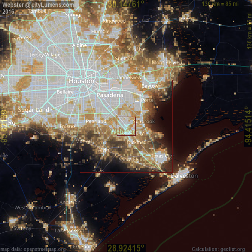
Analysis of Webster night lights 2016
Square area 10x10 km:
 29.92%
90-99
24.62%80-89
12.5%70-79
24.62%60-69
8.33%50-59
0%40-49
0%30-39
0%20-29
0%10-19
0%0-9
0%Square area 50x50 km:
18.94%90-99
12.85%80-89
8.26%70-79
9.89%60-69
7.84%50-59
7.68%40-49
6.18%30-39
5.54%20-29
5.1%10-19
6.26%0-9
11.45%Clear (daylight) street map image can be seen on geolist.org.
Map coordinates:
30° 8' 51.4" North, 95° 49' 17" West
29° 32' 15.8" North, 95° 7' 5.7" West
28° 55' 26.9" North, 94° 24' 54.5" West
Some cities around Webster sort by population:
• Pearland
16.5 km =10.3 mi,  280°
280°
• League City
4.1 km =2.5 mi,  146°
146°
• Friendswood
8.1 km =5 mi,  263°
263°
• La Porte
17.1 km =10.6 mi,  33°
33°
• Alvin
17.6 km =10.9 mi,  223°
223°
• Dickinson
10.7 km =6.6 mi,  142°
142°
• Seabrook
9.4 km =5.8 mi,  71°
71°
• Bacliff
12.6 km =7.8 mi,  105°
105°
4740423 (p: 11,116)
Sources (retrieved 2019-11-25):
» Earth at Night: Flat Maps 2012, 2016