Seabrook night lights from space
Night Light of Seabrook (Texas) from space (United States) Src. Average luminocity for 10x10km area is 70.3163% and for 50x50km: 55.7154%.
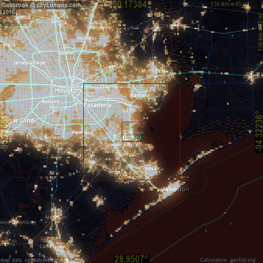
Analysis of Seabrook night lights 2016
Square area 10x10 km:
 12.31%
90-99
13.45%80-89
10.42%70-79
18.37%60-69
13.45%50-59
10.04%40-49
11.17%30-39
5.87%20-29
4.92%10-19
0%0-9
0%Square area 50x50 km:
16.04%90-99
12.29%80-89
7.69%70-79
8.86%60-69
7.7%50-59
6.85%40-49
5.05%30-39
4.39%20-29
3.59%10-19
6.27%0-9
21.26%Clear (daylight) street map image can be seen on geolist.org.
Map coordinates:
30° 10' 25.8" North, 95° 43' 43" West
29° 33' 50.8" North, 95° 1' 31.7" West
28° 57' 2.5" North, 94° 19' 20.5" West
Some cities around Seabrook sort by population:
• League City
9.2 km =5.7 mi,  226°
226°
• Baytown
19.6 km =12.2 mi,  13°
13°
• Friendswood
17.4 km =10.8 mi,  257°
257°
• La Porte
11.3 km =7 mi,  2°
2°
• Deer Park
18.3 km =11.4 mi,  328°
328°
• Dickinson
11.8 km =7.3 mi,  192°
192°
• Webster
9.4 km =5.8 mi,  251°
251°
• Bacliff
7.1 km =4.4 mi,  153°
153°
4727596 (p: 13,716)
Sources (retrieved 2019-11-25):
» Earth at Night: Flat Maps 2012, 2016